Retail Data Sets
GLOBAL RETAILER DATABASE
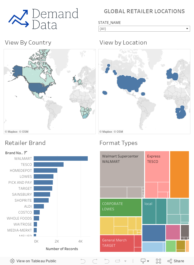
Global List of top 20 retailers and their branch locations
This data set contains lists of store/branch locations across the top 20 global retailers. The data set contains information on each store; what brand and format (local, express, superstore) as well as address, geocoordinates and postcode.
Key uses of this data set include:
Location Planning - Find retail density and competitor activity in certain geographic areas
Competitive Analysis - Find nearest competitor to all of your stores, determine monthly opening or closing rates of stores for your competitors
Brand Analysis - Use sourced sales information from your retail partners or aggregator, join to present a visual map of your product sales, understand gaps in ranging (range extension opportunities) and areas where product sales are growing or declining
Demographics Analysis - Extend your sales analytics by linking to Demand Data demographics sources to pull in local demographics, COVID cases, income, lifestyle, transit types, density etc. Use this data to predictively find branches or open space with similar characteristics.
Refresh Updates and History
This data is updated monthly in the first week of each month. Data will reflect the branches active as of the timestamp date in the dataset.
A dashboard of data can be viewed on our website or via tableau public at
Fields and Definitions
Data Dictionary:
BRAND_NAME: The holding company Brand
CATEGORY: The high level category (GROCERY, GENERAL RETAIL, HOME IMPROVEMENT)
FORMAT: IF applicable the format type of the store (local, express, superstore etc)
LATITUDE: Coordinates in Degrees
LONGITUDE: Coordinates in Degrees
ADDRESS: Street address of the location
LOCATION DATA - States/Provinces; Counties and Countries are standardized based on geocoding.
COUNTRY_NAME AND COUNTRY_CODE: Countries WGS84 standard naming convensions
STATE_NAME AND STATE_CODE:
US - US Census
https://www.census.gov/geographies/mapping-files/time-series/geo/carto-boundary-file.html
Canada - Statistics Canada
https://www12.statcan.gc.ca/census-recensement/2011/geo/bound-limit/bound-limit-2011-eng.cfm
UK - Office of National Statistics
Ctry19cd
DE - https://purl.stanford.edu/jv457hb9421
Level 1 Divisions
ZA - Municipal Demarcation Board
http://dataportal-mdb-sa.opendata.arcgis.com/
COUNTY_NAME AND COUNTY_CODE
US - US Census (FIPS)
CA - N/A
UK - Office of National Statistics
LAD20cd
DE - Level 2 Divisions
ZA - Municipal Demarcation Board - Local Authorities
Sources and Conditions
SPECIFIC TERMS:
This data is sourced from publically available data sources. This data may come from multiple sources which may offer differing data. There are no implied guarantees on its accuracy or completeness.
Geographic Data and Names is provided in accordance with data sources as referenced in the accompanying data dictionary.